Welcome to Stellar Cartography, where you will find out how the local nations of our Star Trek universe grew up to be the mighty interstellar juggernauts that they now are. Starting with the founding members themselves and their own colonising efforts before the forming of the Federation, we'll move on through time in roughly 20-year increments until we reach local space as we know it as of 2380.
My inspiration for this section came mainly from Christian Rühl's Stellar Cartography site at Star Trek Dimension, as well as Geoffrey Mandel's Star Trek Star Charts book. Copious help was received from The Internet Stellar Database for listings and co-ordinates of nearby star systems capable of having a habitable planet around it, which allowed me to plan out the colonies of the founding Federation members. I agree with neither of the above inspirational sites on certain major points, but respect and acknowledge the huge effort both people put into their works.
I had many more maps to follow when I first started these oh so long ago now – before Geoffery Mandel released his excellent 'Star Trek Star Charts' – but due to the possible shifting of alleigance from Star Fleet Battles (S.F.B) and its PC-based successor Starfleet Command (S.F.C.) to the post-novel continuity and the MMORPG Star Trek: Online (S.T.O.) based on the Star Charts book, I'm no longer sure of where the Gorn are in my universe. I'm still making up my mind.
It's hard to lose an entire star nation of huge sapient reptiles, but there you go…
For an explanation on the layout of this chart and motivations behind it, read this short essay on the topic. If you don't find your question answered, drop me an e-mail and I'll update it.
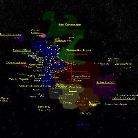 |
This chart details the expansion of all the interstellar empires of the major players in the area of Local Space centered on the Sol system. Additional: Since ceating this map I have repositioned the Tholians to their Star Charts location, but this is not yet reflected here. |